






Interstices Urbains Temporaires
2009-06-08 14:04:42 - by
Antoine Berlon
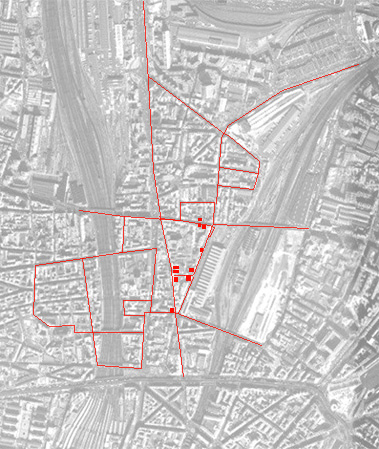
Cette carte présente une tentative de représentations des interstices existant dans le quartier de La Chapelle situé dans le 18ème arrondissement parisien. Ce projet s’intéresse aux expérimentations architecturales et artistiques menées autours des interstices urbains.
Il faut entendre par "interstices", les zones territoriales résistant encore aux politiques foncières de l’aménagement urbain. La ville, dans son ensemble, dispose de quantités d’espaces vierges d’activités : on parle de terrains vagues, de friches, d’indéterminations spatiales,...Leur fonctionnements diffèrent des espaces classiques de la ville, et "l’auto-gestion" prend ici une ampleur significative.
Les objectifs de cette recherche-action sont d’explorer une série de situations urbaines interstitielles (spatiales, temporelles, institutionnelles, interculturelles…) et d’expérimenter des micro-dispositifs participatifs d’intervention artistique et architecturale à différentes échelles (quartier, ville). Pour plus d’informations, visitez le site des Interstices Urbains Temporaires
Fallen fruit : A Mapping of Food Resources in Los Angeles.
2009-05-06 16:38:43 - by
Antoine Berlon
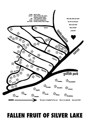
We began this project by mapping our neighborhood, Silver Lake, going street by street to identify untapped public resources and cataloging their location. We set out to only mark sites that involved no trespassing. Right away we began to speculate on the ethics involved, both on the part of residential growers and local harvesters.
Free food is available at every time of the year on the streets of Los Angeles. According to the law, if a fruit tree grows on or over public property, the fruit is no longer the sole property of the owner. Fruit trees in particular are highly decorative, and often demand no greater care than any other landscape ornamental. Los Angeles is particularly rich in this respect : bananas, peaches, avocados, lemons, oranges, limes, kumquats, loquats, apples, plums, passion fruit, walnuts, pomegranates and guavas, just to name a few, grow year round in every neighborhood in the city. These fruits ripen at different seasons, so free food is available year round in Los Angeles
Some communities have plantings of decorative fruit trees, such as sour oranges, which look charming but have little use. Public plantings almost never incorporate edible fruit trees, with one exception being the guava trees that shade parts of the Rose Bowl parking lot. Echo Park is known for the quantities of walnut trees at its northern end. Many parks and wild spaces have prickly pear cactus plantings, which yield both young cactus pads for nopales and prickly pear fruit. Accidental fruit trees arise from stray seedlings, an echo of Johnny Appleseed’s mission to populate the American frontier with apples, native to Eurasia. One of the most common street trees in California is the carob tree, source of a nutritious flour that can be used as a cocoa substitute, or the pods can be chewed whole.
Often a resident is reluctant to plant fruit trees because of the litter, fallen fruit that has to be disposed of ; likewise, locals are often reluctant to pick food within their grasp because they perceive it to be private property. The slow, “natural” processes of growth and fruition dramatize the shadowy nature of private property. Who does the sun belong to, and rainwater ? Why is this lemon in our public space ? Is this my banana ?
It is no small irony that most Americans eat less than the minimum recommended amounts of fruit and vegetables, even though they are all but free for the taking. Supermarket produce is quite expensive if you count it by caloric content, but the cost of processed food is ridiculous once you factor in the nutritional debit it incurs. Public fruit is more efficient to grow than farmed fruit because it eliminates the cost of transport. Since it is not a mono-crop, as in an orchard of a single variety of apple, there are far less pests and less chemicals required. A further irony is that most of the public fruit in Los Angles is organic, blessed by neglect. Is it safe to eat ? Absolutely. Should you worry about car exhaust fumes ? No. Those molecules are too large to penetrate the fruit and any smut that lands on the fruit can be washed off.
We call upon the city and urban planning groups to begin plantings that yield edible goods to be shared by the city’s citizens. How can these resources be developed to the benefit of all parties ? What ethical or contractual obligations are incurred ? It has been observed among many hunter-gatherer societies that when people “have more of something than they immediately need, they should carry out their moral obligation to share it out.”
All property owners with suitable sites should be obliged to plant edible trees, or else be taxed to provide food for the poor. Most European cities have communal gardens, which often provide up to half the food of poor families. We need city fruit parks that open their fields to anyone who is hungry. To discourage profiteering, individuals could be limited to taking only as much fruit as they can carry in their hands. This way everyone could give according to their capacities and receive according to their needs.
The utopian promise of California always pictured orange trees with snow-capped mountains in the distance. The new California should have oranges planted between office buildings and bananas in parking lots. Silver Lake is full of the ghosts of old Hollywood : James Dean, Rock Hudson, Judy Garland, Norma Talmadge and Buster Keaton lived here. Their ashes and discards filter through the soil to this day. Dead illusions feed the carnival of fruit that lines our streets.
Over time, we hope to involve more people, especially local activists best equipped to map their own neighborhoods ; the life of such a map is quite long, since fruit trees live for decades. While the Internet would seem to be the likeliest venue for such a project, a printed form is essential ; the most disenfranchised Angelenos have no access to a computer. Maps must be given to them in person.
When you reap the harvest of your land, you shall not reap all the way to the edges of your field, or gather the gleanings of your harvest. You shall not pick your vineyard bare, or gather the fallen fruit of your vineyard ; you shall leave them for the poor and the stranger. Leviticus 19:9-10
http://www.journalofaestheticsandprotest.org/3/viegeneretal.htm
Carte commune
2009-04-27 16:49:09 - by
Antoine Berlon

Suite à la première exposition Towards qui rendait compte des cartes subjectives d’interventions urbaines des artistes Nathalie Mertens, Nedjma Hadj, Tiziano Lavoratornovi, Harrisson et Benoît Deuxant, Agence, Rival, Katlheen Mertens et Syndicat d’Initiatives, le bureau de graphisme Speculoos s’est attelé à la tâche de faire communiquer ces différentes cartes, de rassembler les informations de chacune d’entre elles au sein d’une carte commune, afin de créer de nouveaux recoupements et des liens inattendus. Chaque artiste s’est vu proposer de remplir un tableau qui permettrait d’extraire une série de données communes : date de l’intervention urbaine, description de celle-ci, etc. L’hypothèse était que les liens se produiraient essentiellement par la concordance des données géographiques : deux cartes décriraient de manière différente le même point, ajouteraient des points de vue à la même paire de coordonnées. Contre toute attente, c’est la poésie brute des descriptions qui a servi de fil conducteur pour la création de cette carte commune, à la fois bande dessinée géographique et phylactère topologique de récits urbains.
Un atlas bruxellois ?
2007-12-28 12:41:55 - by
Véronique
TOWARDS se lance dans la réalisation d’un atlas bruxellois reprenant diverses cartes : réelles, imaginaires, artistiques, anecdotiques, émotionnelles, géographiques, urbanistiques, amateurs, professionnelles, régionales, de quartier, etc
Faire des cartes. Nous sommes plusieurs à nous y intéresser, que ce soit pour développer des plans pour la ville, pour compiler des souvenirs, pour affirmer une position politique, sociale, culturelle, économique ou pour archiver des projets... La vérité est qu’il existe autant de possibilités de cartographier le territoire bruxellois qu’il n’y a de cartographes pour se prêter au jeu : l’une recense les lieux munis de caméras de surveillance, l’autre relève différents « spots » de skate, un autre répertorie les squats, une autre encore cartographie la manière dont les usagers s’approprient l’espace public... Des promeneurs « annotent » les rues de leurs pensées et sensations du moment. Une visiteuse occasionnelle construit un paysage imaginaire de Bruxelles selon les lieux rencontrés durant son séjour et selon les liens qui l’ont conduite de l’un à l’autre... Des fonctionnaires britanniques élaborent des cartes mentales qui schématisent leur vision de la ville... Si les plus classiques réduisent l’espace matériel à sa représentation bidimensionnelle, d’autres tentent de « redonner corps » à cette spatialité abstraite en y introduisant des référents d’usage, imaginaires, mentaux, anecdotiques ou métaphoriques. Les plus hardis vont même jusqu’à s’affranchir des critères spatiaux pour formaliser un vécu personnel...
Au fil des semaines, des mois, des années, de nouveaux visages de Bruxelles verraient le jour et une nouvelle mémoire prendrait forme : celle des luttes urbaines, des intervenions non-officielles, du positivisme des associations, de la richesse des acteurs bruxellois… Celle d’un regard neuf, loin des clichés touristiques et des négociations communautaires.
Tel est l’intérêt d’élaborer des outils consultatifs et collaboratifs de cartographie subjective : comparer, confronter ou intégrer ces différents visages de Bruxelles aux cartes plus officielles ou réglementaires qui découpent la capitale d’aujourd’hui.
En vue de l’élaboration d’un atlas bruxellois, la question de la classification se pose : quels critères peuvent être établis afin de classifier de manière pertinente ces cartes de natures hétérogènes ? Par ailleurs, si le but est de montrer la pluralité des approches cartographiques, est-il nécessaire d’établir de tels critères ?
Bruxelles, Ville d’ouvertures : Cartographie de lieux d’exposition à Bruxelles
2007-07-03 23:02:21 - by
Véronique
Alain géronneZ, 197 ?-2001.
Cette carte réalisée dans le cadre de l’exposition « Ici et Maintenant » à Tour et Taxi (2000-2001) recense et illustre différentes expositions ayant eu lieu à Bruxelles par le biais de flyers et de brochures.
Cartography workshop #2 + EuroMaps
2007-07-03 13:43:17 - by
Nicolas Malevé
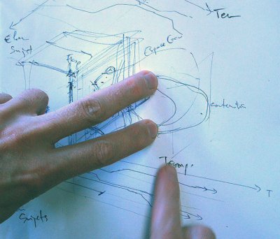
Together, Recyclart , Citymined , Constant organise a worksession in the
Culture 2000 framework of the PEPRAV network, with the collaboration of theK.V.S.. The participants are invited to collaborate on ongoing cartographies, to assist to small presentations and demos, to think about the language of visual interfaces for geographical representations or to help develop a software component that will bridge inkscape, the free vector drawing programme, to a spatial
database. Read more (en français , in het nederlands)
On Friday 06/07/07, Euromaps, an evening of lectures on Post/colonial
mappings curated by Jochen Becker. Read more (en français , in het nederlands)
Cartography worksession
2007-05-14 22:04:34 - by
Nicolas Malevé
A workshop organised in the framework of the PEPRAV network
Making maps... Quite a few of us are busy in a way or another with making maps. Be it to develop subjective visions of the city, to assert political positions or to archive projects. We thought it would be interesting to take some time to work together and see how we could exchange from our different perspectives with map making and map reading.

This worksession is a moment in time used to make the first practical steps to design the Tresor software, a tool for collective subjective cartography.
Un événement organisé dans le cadre du réseau PEPRAV
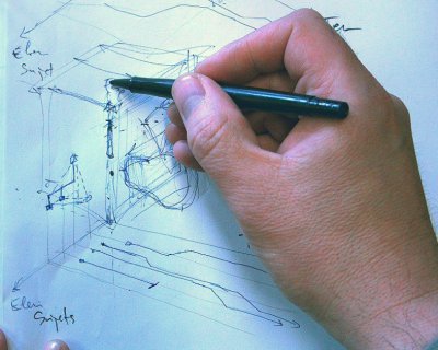
Faire des cartes... Nous sommes plus d’un/e à nous y intéresser. Que ce soit pour développer des visions subjectives de la ville, pour affirmer une position politique ou pour archiver des projets. Nous pensons qu’il serait bon de prendre un peu de temps pour travailler ensemble et de voir si on peut échanger des idées et des pratiques depuis nos différentes approches de la cartographie et de la lecture que nous faisons des cartes.
